REVIEW · CHRISTCHURCH
Christchurch Scenic Helicopter Tour
Book on Viator →Operated by Garden City Helicopters · Bookable on Viator
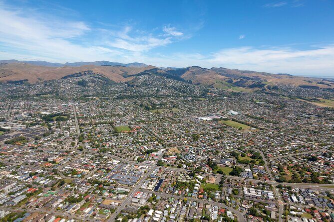
Christchurch looks different from the sky. This 20-minute helicopter ride over the city and Banks Peninsula gives you a fast, up-close view of the earthquake scars and the rebuilding—plus your pilot talks you through what you’re seeing. I love that the flight includes live commentary (not a prerecorded spiel) and that the helicopter is small enough to feel personal, with just four passengers.
I also like how the route isn’t only “pretty coastline.” You’ll spot the cathedral damage, the newer sports stadium, and the red-zone areas from above—then get the harbor and port views at Lyttelton. One drawback to plan around: it’s short by design, so if you’re hoping for a long, super-detailed circuit, a 20-minute flight may feel tight.
Key things I’d circle on your plan
- Live pilot commentary that explains what you’re looking at in real time
- Max 4 passengers, so you get more space and less crowd energy
- Earthquake recovery views: the cathedral, the red zone, and rebuilding around the skyline
- Banks Peninsula highlights from above: Lyttelton Harbour (Whakaraupō), Diamond Harbour, Quail Island
- Coastal suburb flyovers: Sumner, New Brighton, and the Pegasus Bay shoreline
- Weather dependent, with reconfirmation required 24 hours before departure
In This Review
- A short Christchurch helicopter tour that actually teaches you what to look for
- Why the 20 minutes feel like value
- Checking in and getting up to the air (safety first, then scenery)
- Most important tip: plan for weather shifts
- From green spaces to earthquake scars: what you’ll see above Ōtautahi
- Dean Bush, the Red Zone, and Hagley Park from the air
- Cathedral Square: ChristChurch Cathedral damage and the Transitional Cathedral
- The Ōtākaro Avon River Corridor: why the “red zone” is more than emptiness
- Christchurch’s future skyline: sports stadium and the city changing in real time
- Lyttelton Harbour and Diamond Harbour: the Banks Peninsula coast from above
- Whakaraupō (Lyttelton Harbour): a working port and a view with history built into the shape
- Diamond Harbour and Quail Island
- Port Hills and military coastline: Godley Head and Awaroa from a high angle
- Southshore to Sumner and New Brighton: the seaside suburb picture you can’t get any other way
- Sumner Beach: surfing and sea-fishing vibes from above
- New Brighton beaches and the long pier in Australasia
- Seating, weight limits, and small-group comfort you should plan around
- Weight limits and how seating works
- Timing and start times
- Price and value: is $217.20 worth 20 minutes?
- When the cost might feel high
- What to expect on the day: the “make it work” checklist
- Should you book the Christchurch Scenic Helicopter Tour?
- FAQ
- How long is the helicopter flight?
- Where does the tour start and end?
- Do you get live commentary from the pilot?
- Is the tour affected by weather?
- When do I need to reconfirm my booking?
- How many passengers are on the helicopter?
- Is there a weight limit for passengers?
- What happens if it’s canceled?
A short Christchurch helicopter tour that actually teaches you what to look for
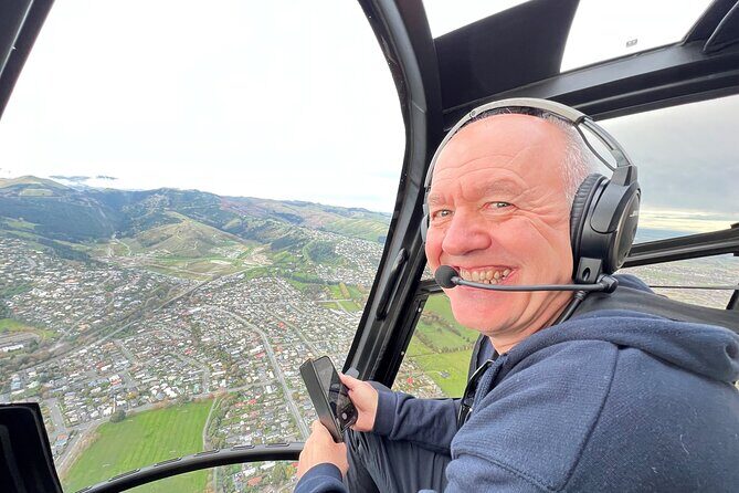
A helicopter flight over Christchurch is the quickest way to get the big picture: the scale of change, where damage hit, and how the city has reshaped itself since the 2010 and 2011 earthquakes. From the air, you can see how “recovery” isn’t one thing—it’s patches, corridors, new structures, and lots of empty space that tells a story on its own.
What makes this tour especially useful is the way the pilot guides your eyes. You don’t just look down and guess. You get live explanation while you fly—so you can connect locations like Cathedral Square, the red zone, and the Ōtākaro Avon River Corridor to what they meant on the ground.
There’s also something quietly satisfying about the small-group setup. With a maximum of four passengers, it’s not a cattle-car ride. You’re also more likely to get seating that works for viewing, even though the pilot ultimately handles seating based on weight and balance.
Why the 20 minutes feel like value
At $217.20 per person, this isn’t a budget activity. The value comes from what you’re buying: an aerial “overview” you can’t replicate on foot, and you get it with a pilot who points out key areas instead of letting you just guess.
If your goal is photography and orientation—seeing how the city, harbor, and peninsula connect—20 minutes can be enough. If your goal is a longer, deeper tour of every corner, you may feel the time limit.
A few more Christchurch tours and experiences worth a look
Checking in and getting up to the air (safety first, then scenery)
Before takeoff, you’ll do a safety briefing. From there, the helicopter departs from their Christchurch International Airport helibase. Total time for the ride is short—flight time is about 20 minutes—so the flow is usually quick: brief, lift off, fly, land.
A couple practical points matter here:
- You’ll be weighed on check-in, and the pilot will use that for weight-and-balance requirements.
- There’s a weight limit of 221 lbs total per passenger.
- The pilot decides seating positions, based on those requirements.
That can sound bureaucratic, but it’s also part of what makes a small helicopter ride work safely. If you fall within the weight limit, you’ll generally get a seat that works for viewing, not just “whoever grabs the last spot.”
Most important tip: plan for weather shifts
This tour is weather dependent. If conditions aren’t right, flights can be canceled, or you may be slotted differently when weather clears. I’d build in some flexibility on your Christchurch itinerary so you aren’t trying to squeeze this between tight reservations.
Also note: you must reconfirm your booking 24 hours prior to departure to check weather conditions. That single step can save you from last-minute surprises.
From green spaces to earthquake scars: what you’ll see above Ōtautahi
Your aerial route starts with Christchurch’s green spaces and central areas, then moves into the parts of the city where the 2010/2011 earthquakes are visible even from above.
Dean Bush, the Red Zone, and Hagley Park from the air
Early in the flight, you get a top-down look at Ōtautahi (Christchurch) and its green areas—Dean Bush, the Red Zone, and Hagley Park. Hagley Park matters here because it sits right in the city’s orbit, and it connects the “park Christchurch” vibe with the more complicated reality of rebuilding nearby.
You’ll also see Christchurch Botanical Gardens from above (listed as a 21 hectare park). Even if you’ve walked Hagley Park before, viewing it from the air helps you understand scale: how much of the city is open space, and how those open zones sit beside the urban core.


Cathedral Square: ChristChurch Cathedral damage and the Transitional Cathedral
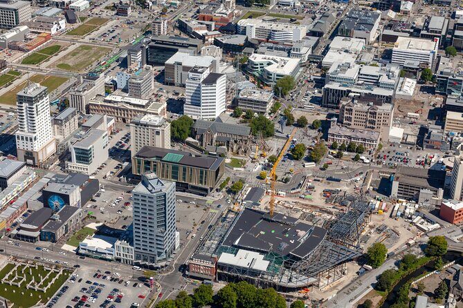
This is one of the most emotional sights from above. You’ll fly over ChristChurch Cathedral, badly damaged in the 2011 earthquake, and you’ll look down on repair work. The tour also points out the nearby Transitional Cathedral, which has taken the cathedral’s place.
From the ground, a cathedral can feel like a landmark. From the air, it becomes a reference point for the whole recovery story: you can see how surrounding blocks and roads relate to the damage and rebuilding.
If you’re traveling with someone who needs context—someone who wants to understand what happened without reading a long book—this section does the job fast.
The Ōtākaro Avon River Corridor: why the “red zone” is more than emptiness
Another standout moment is the view over the Red Zone, including how it has shifted into a more connected, living space. The tour describes it as a holistic project known as the Ōtākaro Avon River Corridor—a way to connect people, river, and land.
From the air, that concept clicks. You can see how corridors and open areas line up, and why the city might choose long-term restoration instead of quick replacement everywhere at once.
If you love photography, this is the kind of overhead geography that helps your pictures feel like stories, not just scenery.
Christchurch’s future skyline: sports stadium and the city changing in real time
The flight also includes city sights that point to what’s being built now. The tour route brings you past the new sports stadium, and your pilot comments on rebuilding efforts and the city’s vision for the future.
This part is worth paying attention to because it balances the heavier earthquake visuals. You’re not only seeing what was broken. You’re seeing what replaced it, and you’re getting it in the same visual frame.
And since the pilot is narrating, you’ll likely catch details you’d miss if you were just looking out the window and guessing.
Lyttelton Harbour and Diamond Harbour: the Banks Peninsula coast from above
Once the flight heads toward the coast, the scenery changes fast—from city blocks and open areas to water, harbors, and volcano-shaped bays.
Whakaraupō (Lyttelton Harbour): a working port and a view with history built into the shape
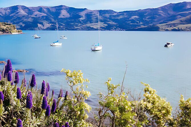
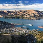
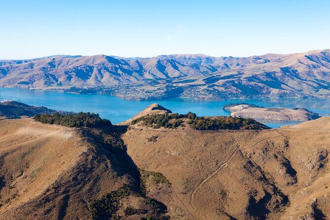
You’ll hover over Lyttelton Harbour / Whakaraupō, one of the major inlets of Banks Peninsula. The description here is clear and useful: it’s a harbour formed by an ancient volcano and then flooded by the sea. You don’t need to be a geology expert to “see” the shape once you’re looking down at the water.
This is also where the city’s connection to the sea comes alive. Lyttelton is described as a busy port for Christchurch, and from the air you’ll grasp why it matters.
Diamond Harbour and Quail Island
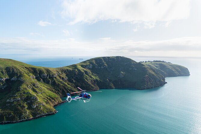
Next up are views of Diamond Harbour and Quail Island (listed as Canterbury’s largest island in Diamond Harbour). Even in a short flight, these are strong anchors: they create a coastal rhythm that feels different from Christchurch’s flatter central areas.
Quail Island is a good example of why aerial views are special. From the ground, you might see a coastline. From the air, you can see relationships—how the island sits in the harbor and how that shapes the waterway.
Port Hills and military coastline: Godley Head and Awaroa from a high angle
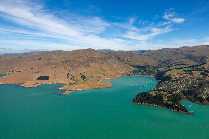
As you move back toward the outskirts, you’ll see the Port Hills—a range of hills in Canterbury between Christchurch and the sea port at Lyttelton. The tour notes they’re an eroded remnant of the Lyttelton volcano, which ties the coastline visuals together with the earlier harbor explanation.
Then there’s the coastal military-defense viewing area: Awaroa / Godley Head, described as magnificent coastal defense sites built during World War Two.
Even if World War Two isn’t your top interest, aerial views make these sites easier to grasp. You can see how coastline and positioning matter, instead of only reading a plaque.
Southshore to Sumner and New Brighton: the seaside suburb picture you can’t get any other way

On the return route, you’ll skim the outskirts of Christchurch, including areas like Sumner and Redcliffs. The stops and descriptions focus on beaches and shoreline, so you get a clean, scenic contrast after the urban and harbor segments.
Sumner Beach: surfing and sea-fishing vibes from above
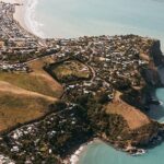
Sumner is described as a coastal seaside suburb, popular for surfing, swimming, and sea fishing. From the helicopter, you’ll see why the beaches and access roads matter: you get a map-like view of shoreline, not just a single beach strip.
New Brighton beaches and the long pier in Australasia
You’ll also see New Brighton beaches, from Waimairi to Southshore, listed as part of Pegasus Bay. One highlight called out in the description is the New Brighton pier, described as the longest in Australasia.
That sounds like trivia until you see it from above. A long pier becomes a strong visual line you can follow with your eyes, and it helps connect the town’s beachfront layout with the larger bay view.
Seating, weight limits, and small-group comfort you should plan around
This tour’s maximum of four travelers is part of the appeal. But the small group also means your experience depends on practical details.
Weight limits and how seating works
Passengers have a total weight limit of 221 lbs. You’ll be weighed on check-in, and seating is decided by the pilot due to weight and balance requirements. That means you should expect less control over “window seat” bragging rights, even though the goal is to get you positioned to see the route.
If you’re inside the limit, don’t overthink it. Just arrive early enough to complete check-in smoothly.
Timing and start times
The tour offers multiple start times, so you can pick a slot that fits the rest of your day. In one of the most positive experiences described, late afternoon light was a big part of why the views felt extra good.
If you can choose between morning and late afternoon, I’d lean toward the later option for softer light—especially for photography.
Price and value: is $217.20 worth 20 minutes?

Let’s talk money honestly.
At $217.20 per person for a roughly 20-minute flight, you’re paying for three things:
- the aerial perspective over key areas,
- live pilot commentary that helps you understand what you’re seeing, and
- the small-group comfort of a max four-passenger helicopter.
You don’t get a long multi-hour excursion. You get a tightly focused aerial loop. That’s good value if your priorities are orientation, earthquake-recovery context, harbor geography, and coastal views—especially if you’re the type who wants to see the “whole system” quickly.
When the cost might feel high
One review experience you should respect is a disappointment that the route felt more like a basic city-to-coast loop than a long, varied itinerary. That’s a risk any short helicopter tour has: if you expected a much longer or more expansive route, the time can feel like it passes fast.
So I’d judge this tour by the kind of traveler you are:
- If you want meaningful overview quickly, this fits.
- If you want lots of stops and lots of time, consider whether another longer option makes more sense.
What to expect on the day: the “make it work” checklist
You won’t have a lot of wiggle room once you’re airborne—so your preparation matters.
Here’s how I’d approach it:
- Choose a time you can stick with, but keep your schedule flexible because it’s weather dependent.
- Reconfirm 24 hours before to avoid wasting time waiting for updates.
- If you’re bringing anyone close to the weight limit, plan around the 221 lbs rule.
- Bring your camera plan, because the flight is all about visuals and spotting details from above.
And remember: the pilot will keep things moving, including seating decisions based on safety rules. Try to go in with the right mindset: this is not a slow sightseeing drive. It’s a flight, and it’s fast.
Should you book the Christchurch Scenic Helicopter Tour?
I’d book it if you want a high-impact view of Christchurch in a short window: cathedral reconstruction context, the red zone story, and then Banks Peninsula from Lyttelton Harbour out toward Diamond Harbour and the Quail Island area. The live pilot commentary is a big reason this tour is more than “pretty photos”—you’ll understand what you’re seeing while you’re seeing it.
I’d hesitate if you’re expecting a long, never-ending ride with lots of time over each place. At 20 minutes, the tour is intentionally compact, and you’ll need to accept that some “seeing” means identifying the key areas quickly rather than lingering.
If you can match your schedule to weather and pick a later light slot, this is one of those experiences that turns your Christchurch visit from “I saw places” into “I finally understood how it all fits together.”
FAQ
How long is the helicopter flight?
The flight time is about 20 minutes (approx.).
Where does the tour start and end?
The activity starts at 73 Grays Road, Harewood, Christchurch 8042, New Zealand, and it ends back at the meeting point.
Do you get live commentary from the pilot?
Yes. You’ll listen to live commentary from your pilot during the flight.
Is the tour affected by weather?
Yes. The trip is weather dependent, and flights can be canceled if conditions aren’t suitable.
When do I need to reconfirm my booking?
You must reconfirm your booking 24 hours prior to departure to check weather conditions.
How many passengers are on the helicopter?
This tour/activity has a maximum of 4 travelers.
Is there a weight limit for passengers?
Yes. The total weight per passenger is listed as 221 lbs, and passengers are weighed on check-in.
What happens if it’s canceled?
The cancellation policy allows free cancellation up to 24 hours in advance for a full refund. If it’s canceled due to poor weather, you’ll be offered a different date or a full refund. If the minimum number of fares isn’t reached, it may be canceled with an alternative date/experience or a full refund.